Posted by
Travellingcamera
at
Thursday, September 17, 2009
comments (1)
Recently I visited Bijli Mahadev, which is a small trek from Kullu. Since there is a road now, so we had to trek 3 km only. Its really an amazing place to visit and this was the best place I visited during my recent Kullu-Manali trip of four days. I visited many places like Rohtang, Solang, Vishishth, Naggar, Kullu, Manali, Manimahesh etc, but the best part was trekking experience to Bijli Mahadev...
Bijli Mahadev is one of the sacred temples of the Indian state of Himachal Pradesh. It is located at an altitude of about 2,438 m in the Kullu Valley. Bijli Mahadev is one of the excellent temples in India. Located 10 km from Kullu across the Beas river, it can be approached by a difficult but rewarding trek of 3 km.
Hill top where Bijli Mahadev Temple is situated...
Whole space was covered with Deodars & Clouds...
I had never imagined such a huge ground on the top of a hill...
Sun was strugging hard with Clouds to see us...
Horse Riding @ Bijli Mahadev
We were impressed with cleaniness of the place, fresh clouds, high deodars & blue sky....
Finally Sun came out but dispersed through Deodars...
A panoramic view of Kullu and Paravati valleys can be seen from the temple. The 60 feet high staff of Bijli Mahadev temple glistens like a silver needle in the sun.
Bad Editing... I made this grass yellow :(
These two guys were moving on the edges to see Kullu, Manikaran, Malana & bhuntar Airport... All these places are clearly visible form top... I will share more pics of these places soon...
You can see very small houses behind Deodars... this is Kullu Town... If you can't see in this pic, visit the place :)
Apple Tree and Clouds...
Tents @ Bijli Mahadev
Cloud shapes...
In this temple of lightning it is said that the tall staff attracts the divine blessings in the form of lightning. It is believed that the priest of the temple has to restore the Shiva linga placed inside the temple using butter and sattoo after every lightning as it shatters to pieces with flash of lightening.One can reach Kullu first and then get a bus from the bus stand for Bijli Mahadev which goes upto the nearby Chansari village. Otherwise one can book a private cab from the Kullu taxi stand near bus stand and go. One has to climb stairs from Chansari, the distance being about 3 km uphill.
Bijli Mahadev is one of the sacred temples of the Indian state of Himachal Pradesh. It is located at an altitude of about 2,438 m in the Kullu Valley. Bijli Mahadev is one of the excellent temples in India. Located 10 km from Kullu across the Beas river, it can be approached by a difficult but rewarding trek of 3 km.
Since its on the top of a hill at 2,438 m, most of the neighboring areas can be viewed from the top...
Bridge over Beas river connecting Bhutar to Maikaran..
Bhuntar Airport...
A View of Kullu town from Bijli Mahadev....
Bhuntar Region which is clearly visible from back side of Bijli Mahadev Temple..
Again a view of Kullu town...
Nitin trying to capture Manikaran Valleys in his Camera by sitting on the edge @ Bijli Mahadev
A View of Kasol & Malana Region from Bijli Mahadev...
Posted by
Travellingcamera
at
Monday, August 17, 2009
comments (0)
Baijnath is famous for its 13th century temple dedicated to Siva as Vaidyanath, ‘the Lord of physicians’. Originally known as Kiragrama, the town lies on Pathankot-Chakki-Manali highway (National Highway No. 20) almost midway between Kangra and Mandi. The present name Baijnath became popular after the name of the temple. The town is located on the left bank of the river Binwa, a corrupt form of ancient Binduka, a tributary of river Beas.
Front View of main temple @ Baijnath
Closer look to the Temple...
Another temple on the left of main Temple...
Entry for Temple from Main Market...
Temple view from backyard...
Green garden in the back side of Shiva Temple...
Rays coming out through clouds..
Sunset time @ Baijnath
According to the legend, it is believed that during the Treta Yug, Ravana in order to have invincible powers worshiped Lord Shiva in the Kailash. In the same process, to please the almighty he offered his ten heads in the havan kund. Influenced by this extra ordinary deed of the Ravana, the Lord Shiva not only restored his heads but also bestowed him with powers of invincibility and immortality.
On attaining this incomparable boon, Ravana also requested the Lord Shiva to accompany him to Lanka. Shiva consented to the request of Ravana and converted himself into Shivling. The Lord Shiva asked him to carry the Shivling and told him that he should not place the Shivling down on the ground on his way. Ravana started moving south towards Lanka and reached Baijnath where he felt the need to answer the nature’s call. On seeing a shepherd, Ravana handed over the Shivling to him and went away to get himself relieved. On finding the Shivling very heavy, shepherd kept the ling on the ground and the Shivling got established there and the same is in the form of Ardhnarishwar (God in form of Half Male & Half Female).
In the town of Baijnath, Dussehra festival in which traditionally the effigy of the Ravana is consigned to flames is not celebrated as a mark of respect to the devotion of Ravana towards Lord Shiva. Another interesting thing about the town of Baijnath is that there is no shop of goldsmiths.
Posted by
Travellingcamera
at
Thursday, July 2, 2009
comments (0)
I visited Palampur, Baijnath, Kangra, Dharmashala & other surrounding areas many times but never got a chance to enjouy the toy train journey between Pathankot & Jogindernagar.
Patahnkot is in Punjab & Jogindarnagar is in Mandi district of Himachal but when you opt for the train journey, your train crosses most of the Kangra District region which is known for its beautiful valleys.
Recently when I visited Palampur, one of my friend was telling me about this railway track. This railway track was built during 1926-1929 and was opened for transporting raw material for construction of Shanan Power House(Joginder-nagar) on April 1st, 1929
Unlike the Shimla-Kalka train, where the passengers spend most of the time going through tunnels, the Kangra toy train linking Pathankot and Jogindernagar gently meanders through a maze of hills and valleys, offering the travelers enchantingly scenic view.
The work on this line started in 1926. Three years later this, 163 km. long route was opened to traffic. The entire route commands glorious views of nature and unveils myriad facets of history, art and culture. The grand spectacle of Kangra Valley begins unfolding after the train enters the foothills. Hillocks rise on both sides and as the train moves over the meandering streams, the Dhauladhar begin to gain in prominence. Emerging through Daulatpur tunnel and past the ruins of the old Kangra fort, one is surprised by the change in the landscape.
The Dhauladhar rises up 13,000 feet from the valley floor. The wide Kangra Valley, with its well-watered terraces, is simply superb. As the train inches on, the passengers adore the open countryside and the shining white peaks. An unmistakable pine scent fills the air and the track is suddenly fringed on both sides by the tea gardens of the Palampur region. The stretch between Baijnath and Joginder Nagar is the steepest. Here the train moves at a snail's pace till it reaches the highest point on the track at Ahju. Not far from here are the popular para-gliding and hang-gliding sites of Bir and Billing. As the train approaches Joginder Nagar, the white mountains, gradually begin fading away.
As of now I don't have any photograph of Kangra valleys & hills which come on the way but I will try to get some pics soon...
Posted by
Travellingcamera
at
Saturday, September 13, 2008
comments (1)
Shrikhand Mahadev Terk in Himachal Pradesh (25th - 30th July, 2008)
After knowing about this place from my friend Vikas, we planned a trek of Shrikhand Mahadev. Before going there I had totally different views about the place. I had no information about trekking before visiting this place. We were four out of which three were going for such a long trek first time. Vikas was going second time but he was not able to complete this trek last time. Due to little knowledge about trekking we had very bad plan of completing this trek in three days excluding our journey from Delhi to Nirmand.
***As per my estimate this is 5 days trek (Jaon >> Shrikhand Mahadev>> Jaon)
Broken Mud house near Jaon village @ Shrikhand Mahadev
25th evening (Started from Delhi)
We started on 25th evening from Delhi and reached Nirmand at 12 noon on 26th.
26th July (Shimla>> Nirmand >> Jaon >> Singh-Ghat)
After lunch at Nirmand we hired a cab for Jaon village which is starting point of this trek. Shrikhand Mahadev is actually a pilgrimage place for Hindus. Shirkhand Mahadev is considered to be the abode of Lord Shiva. So it is a place of great attraction for the religious people as well as for climbers. It was a trek for us (Vishal, Vikas, Narender and me). It is part of the Great Himalaya National Part (Kullu-Shimla, Himachal Pradesh, India) where the forests and the high altitude meadows are protected and can display there full beauty.
Worker with Apples near Nirmand @ Shrikhand Mahadev
There are lot of apple orchids on the way to Jaon from Nirmand. Nirmand village is believed to be biggest village of Asia. 27th July (SinghtGhat >> Barahati >> Thacharu >> Kali Ghati)
On 26th we trekked to Singh-Ghat and stayed there in night. On 27th, we started our journey for Thachru at 5 am. This complete strech is full of forests and water bodies. During first 30 mins, we were moving on a narrow path alongside Shrikhand river.
Shrikhand River near Singh Ghat @ Shrikhand Mahadev
Then we started climbing hills from Barahati to Thachru. This was most difficult strech of the whole trek. Its 80 degree climb from Barahati to Thacharu. When we looked up, the hill was soaring into the skies. After 2 Hrs from Barahati rain started and we kept on moving with our rain suits. Vikas had already warned us for that rains can start anytime, so be prepared. Vikas was trying to keep our energy-level high by saying that we are going to reach Thachru in next 1 hr. Actually it took approximately 7 hrs for us to reach Thacharu. I guess Thacharu is approximately 10 kms from Singh Ghat. We were completely exhausted when we reached Thacharu. We finished 2 Glucose packates before reaching this place :-)
Moving Clouds @ Shrikhand Mahadev
When we looked up, the hill was soaring into the skies. It was really tough. Even a luggage of 7kg on your back seems of 30 kgs. Target for 26th was to reach Bheemdwari but no one was in a state to move further. At this point of time we realized that we should have a coolie for the luggage and lot of energy food. We had our lunch at Thacharu and it was not so good. I was not able to take more than 10 spoons of rice. We had few other things to eat which helped me in complete trek.
*** Keep Glucose packages with you as much as possible. Also other stuff like fruits, biscuits etc. Because its very difficult to cook nice lunch & dinner...
Forest view on the way to Thacharu @ Shrikhand Mahadev
This strech was quite steep through the forest followed by a long & a wide plateau with wild flowers. We left all the civilization behind on this route.
After lunch we slept for 1 hr and after that no one was in a mood to trek further. Finally Vikas was able to motivate us to move further and we were able to reach Kaali Gahati by evening. There were no tree between Thacharu and Kaali Ghati. From this point we were able to see lots of high hills covered with snow. Shrikhand Shivlingam was visible from this point in early morning. We spent second night at Kaali Ghati in a Tent and fortunately we met a person who agreed to go with us till Shrikhand Mahadev. He helped us by taking all our bags on his shoulders. He charged 300 Rs per day which was nothing if we see his hard work. Two of us were down with Fever (Me and Narender). We had very bad head ache with 103 degree temperature. Luckily we had enough arrangement for the night in terms of cloths and blankets. I hardly slept that night.
Tent at Kali Ghati @ Shrikhand Mahadev
*** Torches are of great help in nights...
28th July (Kali Ghati >> Valley of flowers >> Bheem Dwari >> Parvati Baag)
We started for next target Bheem Dwari at 6:00 am on 27th. After Kaali ghati there was no source to contact anybody because cell phones were not working now. We crossed approximately 8 hills up and down to reach Bheem Dwari. Time between 6:00 am and 8:30 am is the best time when you can see the beauty of hills. After that clouds start moving and vision area starts decreasing. Most of the time area of vision was 10-15 meters.
Clouds in early morning @ Shrikhand Mahadev
There is a beautiful valley in between: Valley of Flowers.
A view of Valley of Flowers @ Shrikhand Mahadev
Valley of flowers is believed to be rich valley in terms of Herbs. According to Dhola Ram ji, local people come uphills in the month of September to get herbs for main Contractors. This valley is really beautiful, full of colorful flowers and leaves.
We had our lunch at Bheem Dwari and it was pretty cold in the evening with temperature hovering around 2-3 degree Celsius which must have dropped down further during night. Vikas with Dhola Ram ji moved towards Parvati Bag for arranging tents there. Other of us took rest at Bheem Dwari for some time. In rained as we started climbing up for Paravati Bag. We moved without any break because we were safe due to top layer of rain-suit. when we reached at Paravati Bag, sky was clear and we were able to see Moon with lot of stars around it. Everybody was shivering with cold and we started sharing some other experience in closed tents. After some time we had dinner and came out of tents to enjoy night view of hills and clouds around us. All of us were in multiple layers of cloths but still we were shivering inside quilt.
Waterfall near Valley of flowers @ Shrikhand Mahadev
This stretch was really beautiful with lot of flower valleys and waterfalls...
Broken Mud house near Bheem Dwari @ Shrikhand Mahadev
Nain-Sarovar view from hill top @ Shrikhand Mahadev
Next day we woke up at 5:00 am and started climbing the last stretch immediately after breakfast. This was the most difficult stretch with steep snow covered and rocky hills. Today we took our first break after 4 kilometers at Nain Sarovar. This was a water lake between hills and most of the part was frozen. Temperature was very less here. we moved ahead after few minutes and we had to cross a high rock hill. After some time sun came up and view was clear when we reached the top of this rock hill, we were overwhelmed with the beauty of the place. On the top we saw a huge store of clouds and we spent approximately 20 minutes here.
Cloud Store @ Shrikhand Mahadev
Try to reach this place in early morning because after 8:00 am its not so clear because all the clouds move up in the sky and visibility radius reduces. After this had to climb approximately 5 more rock hills and few snow covered hills in between. Some of these climbs were 85 degree steep. Now this was fear factor kind of challenge for us where we were climbing up rocks on one side and deep descents on other side. This was really scary for me at least. Vikas and Dhola Ram ji helped other people to climb up. One of them used to go up first and second come after helping others to reach one place.
Rock climbing without ropes @ Shrikhand Mahadev
This area known as Bheem Paudi(steps) was full of big rocks with different kind of marking on them. This was much more tiresome than the last day’s trek and hence we had frequent water breaks. There was no water source after Nain Sarovar so one needs to pack water for journey after Nain-Sarovar.
*** Keep water bottles with you after Nain-Sarovar. There is no water source after that except snow on hills.
Due to lot of breaks throughout the trek we were lagging by one day. As we were near to our destination, I started thinking about back journey to Delhi and we started discussing the same. At the end we decided to reach Shimla by Wednesday Evening which was very optimistic in my opinion. Now Dhola Ram warned us and asked to move slowly by avoiding breaks.
*** But as Dhola Ram kept repeating the key was to walk at your own pace and not rush.
Trekkers moving on snow covered hill @ Shrikhand Mahadev
Finally we were able to see the final destination, the standing Rock on a hill top known as Shrikhand Mahadev. But still we had to cross three hills to reach there. I was down with weakness and asked others to move further. I was planning to quit and wait others for back journey. As was expected it turned out to be the toughest day of the trek. For the first time I was feeling the lack of oxygen and the need to stop and take long breaths after few steps.Vikas and others folks motivated me to move ahead. We started moving again ...
View of Shrikhand Mahadev @ Shrikhand Mahadev
Now we finished the last packet of Glucose :-)
The peaks surrounding Bheem Paudi received fresh snow. Dropping temperature, low atmospheric pressure, less oxygen wasn’t helping us and some of us were down with altitude sickness. Me and Vikas were down after reaching Shrikhand. Dhola Ram asked us to move back without spending much time there. I was very disappointed on my condition. I was felling helpless on the top. I was thinking to capturing the beauty in my camera but my energy level was not allowing me for that. Finally I had no energy to move 100 meters for touching Shrikhand Mahadev rock...
Now we started moving back. My conditions was worst now.. No energy to walk and no option to stay... After going 2-3 kilometers we were comfortably moving down at very slow pace. After some hours we saw our tents at Paravti Bag but still the distance was approximately 6 kilometers. Now other side hills were not visible due to high clouds.
During back journey to Parvati Bag, we took a long break near Nain-Sarovar. Here we saw a lot of Bramh-Kamals... Now we were able to see lush green hills on other side. Finally we reached Parvati Bag after lot of exertion during the day...
We went near a waterfall for some time and spent a good time there. We had tea after taking some rest in tents... today all of us were very tired and went to sleep immediately after dinner.
30th July (Parvati Baag >> Bheem Paudi >> Valley of Flowers >> Kaali Ghati >> Thacharu)
Tents for trekkers @ Shrikhand Mahadev
Next Day we started our journey back to Singh-Ghat... Now we had to climb new heights but these were comparatively easy. We took long break at Kaali Ghati and moved for Chachru. By the time we started from Kali ghati we were late to reach Singh Ghat. Rain started as we moved down towards Thacharu from Kali Ghati. We stayed at Thacharu in night. It kept raining the whole night and we kept wondering (and praying) if we would be able to reach Shimla next day or not. Some of us were down with fever. Night Temperatures were sub-zero and it was really cold.
Early Morning view from Parvati Baag @ Shrikhand Mahadev
We woke up at 4:00 am and moved down to singh ghat after morning tea. Torches were helpful during early morning darkness of forests on the way.
We reached Barahati at 8 am. Vishal and I decided to take bath in frigid water of Shrikhand river. Our senses stopped working wafter 2 minutes in river water and shivers continued for next 45 minutes...
After reaching Jaon Village we hired a taxi for Nirmand where we had parked the car. We reached Shimla at 6:30 pm and we changed our routes... Some of us came back to Delhi and a few went home to take rest...
After reaching home we were feeling great to complete this trek and these memories are precious for all of us. We used to discuss the rainy days, high climbs, clouds, waterfalls, restlessness, temperature and other incidents of the trek...
Really Shrikhand Mahadev Trek was an amazing experience for us and I would strongly recommend trekkers to plan the things seriously. This was really a tough trek...
Here ends the memorable Shrikhand Mahadev Trek 2008...
 Hill top where Bijli Mahadev Temple is situated...
 Whole space was covered with Deodars & Clouds...
 I had never imagined such a huge ground on the top of a hill...
 Sun was strugging hard with Clouds to see us...
 Horse Riding @ Bijli Mahadev
 We were impressed with cleaniness of the place, fresh clouds, high deodars & blue sky....
 Finally Sun came out but dispersed through Deodars...
 A panoramic view of Kullu and Paravati valleys can be seen from the temple. The 60 feet high staff of Bijli Mahadev temple glistens like a silver needle in the sun.
 Bad Editing... I made this grass yellow :(
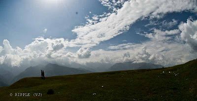 These two guys were moving on the edges to see Kullu, Manikaran, Malana & bhuntar Airport... All these places are clearly visible form top... I will share more pics of these places soon...
 You can see very small houses behind Deodars... this is Kullu Town... If you can't see in this pic, visit the place :)
 Apple Tree and Clouds...
 Tents @ Bijli Mahadev
 Cloud shapes...
 Bridge over Beas river connecting Bhutar to Maikaran..
 Bhuntar Airport...
 A View of Kullu town from Bijli Mahadev....
 Bhuntar Region which is clearly visible from back side of Bijli Mahadev Temple..
 Again a view of Kullu town...
 Nitin trying to capture Manikaran Valleys in his Camera by sitting on the edge @ Bijli Mahadev
 A View of Kasol & Malana Region from Bijli Mahadev...


